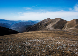
From the High Hills to the Mountains


Lenght: 10700 mt.  
Direction of travel: counterclockwise  
Hiking time: 5h 40'  
Difficulty : EE - For experienced hikers  
Path: Forca di Ancarano – Monte delle Rose - Forca di Giuda – Forca di Ancarano (581 – 582 - 581);

stato: partially open

From Forca di Ancarano to Monte delle Rose


From Forca Ancarano, passing by the Grotta di Patino, the trail climbs gradually through mixed forest that turns into primarily beech forest. Above 1600 meters the treeline finishes and large ‘secondary’ grasslands begin. These are grazing areas that were once created by man to increase the available pasture. At Forca di Giuda the route intersects with the Trail of Italy (SI) and the Sibillini Great Circular Route. The beautiful landscape offers many views to the summit of M. Vettore.


STATUS OF THE ROUTE DETECTED AFTER THE EARTHQUAKE OF 2016
A long part of this trail is closed. You can only walk the parts overlapping the Grande Anello dei Sibillini and the Sentiero Italia

Map of the ordinances and limitations in force due to the earthquake

Map of the ordinances and limitations in force due to the earthquake

MAPPA


Access to dogs allowed Access to bicycles allowed Drones - No fly zone go to the photo gallery Go to the cartographic portal Download georeferenced maps and GPS tracks Download the route for Google Earth
 

TOUCH DISPLAY


go to the route E1   go to the route E2   go to the route E3   go to the route E4   go to the route E5   go to the route E6   go to the route E7   go to the route E8   go to the route E9   go to the route E10   go to the route E11   go to the route E12   go to the route E13   go to the route E14   go to the route E15   go to the route E16   go to the route E17  
Attention, opaque links correspond to paths that are currently closed.


Go to Great Sibilline Ring   Go to the nature trails
consult the website of the weather alerts of the Marche Region consult the website of the weather alerts of the Umbria Region